Sheet 02 · Western Hokkaido · Shiribeshi · Route 229
Otaru to Cape Kamui, the blue coast
Seventy kilometres of cliffs, tunnels and improbably blue sea out to Hokkaido's only marine park — with a whisky distillery on the way, and a season that decides everything.
Some links in this article are affiliate links: if you book a car or a room through one, I receive a commission at no extra cost to you. It does not change what I recommend.
The Shakotan Peninsula is the piece of coast people have in mind when they say the sea in Hokkaido is a colour they were not expecting. It pushes out into the Sea of Japan west of Otaru, an hour and a half of cliffs and tunnels from the city, and it holds the one stretch of water the prefecture protects as a marine park — the only one in Hokkaido. The colour has a name here, 積丹ブルー, Shakotan blue, and on a calm bright day it earns it.
This is a coast road — Route 229 — and it is a summer drive before it is anything else. What follows is how to run it from Otaru out to Cape Kamui: where to start, a whisky distillery worth the stop on the way, what the road is actually like, the two viewpoints that earn the detour, and the season that quietly decides whether the trip works at all.
§ 01
Where to start, and the car
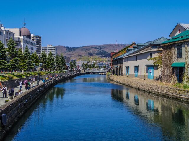
Otaru is the gateway, and a good one. Its canal, finished in 1923, was a working waterway before it was the most photographed thing in town; the warehouses along it are restaurants and shops now, and the city has the food, the beds and the fuel that the peninsula itself does not. Most people arrive at New Chitose Airport, about an hour away by car, or come out from Sapporo, forty minutes or so on the expressway. Either way you want your own car before you leave — there is no useful way to do this coast on public transport.
You will be renting for the whole trip rather than for this one drive, so pick the car up where you land. Most flights come into New Chitose; book it there and drive out through Sapporo and Otaru. Base yourself in Otaru rather than out on the cape: Shakotan town has only a scattering of small inns, while Otaru has the range and the steadier prices, and it puts you thirty minutes from the first stop. One thing to allow for: no company hands the car over at the terminal, so there is a bus to the branch first.
§ 02
Yoichi: whisky on the way out
Thirty minutes west of Otaru, right on the road, is Yoichi, and the Nikka distillery that Masataka Taketsuru built here in 1934 because the place reminded him of Scotland. It is worth the hour it costs you, and it is free — but there is one rule that catches visitors out, so here it is plainly.
There are two ways in. The guided tour is by reservation only and conducted in Japanese, and it ends with a complimentary tasting. If you have not booked, you can still walk in for free through the shop entrance and see the Nikka Museum, the distillery shop and the paid tasting bar, and eat at Rita’s Kitchen — you simply cannot enter the production buildings without a booking, and there is no guide. The facilities run 9:15 to 16:15 with last admission at 15:30, and the site closes over New Year (23 December to 7 January) and on 11 June. One obvious point that is still worth saying: the person driving does not taste. Split the day so someone else does, or skip the glass.
§ 03
The road itself: Route 229
West of Yoichi the road commits to the coast, and the coast here is a wall. Route 229 is one of the most tunnel-heavy national roads in the country — on the order of sixty tunnels around the peninsula — because the alternative to a tunnel is a cliff falling into the sea. It has fallen before: the road you drive today was substantially rebuilt for rockfall protection after a tunnel collapsed at Toyohama in 1996, and the engineering that followed is why the drive is now an unremarkable one to make.
What it feels like is rhythm: dark, then a hard bright rectangle of sea, then dark again. The tunnels are wide and modern and nothing to worry about. The thing to watch is more mundane — fuel. Petrol stations thin out west of Yoichi and rural ones keep short hours, so fill the tank in Yoichi or Otaru before you commit to the far side of the peninsula, not on it. Treat that as the general rule for coastal Hokkaido and you will not be caught.
Sixty-odd tunnels, and one colour of blue in the gaps between them. The blue is the part you remember.
§ 04
Shakotan blue, and Hokkaido’s only marine park
The colour is not a trick of the brochures. The water off this coast is genuinely clear and genuinely deep-blue, clear enough that the seabed is protected: the peninsula’s coast, together with the Otaru shore, is the single marine park zone in Hokkaido, inside the Niseko–Shakotan–Otaru Kaigan Quasi-National Park. There is only one, and this is it.
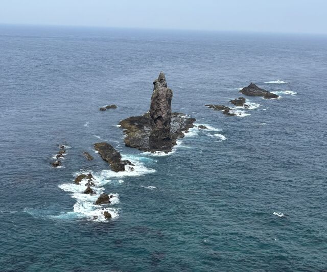
Honesty, though: the blue needs the weather. It is at its best on a calm, sunny day in summer, when the light goes straight into clear water and comes back cobalt. On a grey day with a chop on the sea it is a grey sea like any other. You cannot book the weather, but you can stack the odds — come in the settled part of summer, go in the morning before the wind gets up, and keep the plan loose enough to move a viewpoint to the better day.
§ 05
Shimamui Coast: through the tunnel
The first of the two viewpoints is Shimamui, and getting to it is half the point. You park, and then you walk through a short, dark, hand-cut tunnel bored through the headland — originally dug to move herring in the fishing years — and you come out the far side into the view all at once: a small cove, cliffs, and the blue laid out below you. It is on the national list of a hundred best shores, and it deserves the place.
The viewpoint at the tunnel mouth is the reward, and it is the part you can rely on. The steep path down to the beach itself has been closed at times for snow and storm damage, so do not build the visit around getting your feet in the water; build it around the view from the top, and treat the beach as a bonus if it happens to be open.
§ 06
Cape Kamui: the walk to the tip
Cape Kamui is the end of the road and the reason for the drive. From the car park a single narrow path, the Charenka trail, runs about seven hundred and seventy metres out along a spine of eighty-metre cliffs to the tip, roughly twenty minutes each way, with the sea on both sides and something close to three hundred degrees of it at the end. It is the most exposed and the most memorable place on the peninsula.
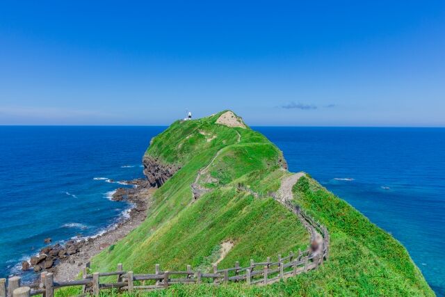
It is also gated, and the gate is the thing to plan around. Its hours change month by month — through August, for example, it is open 8:00 to 17:30 with last entry at 16:30, and in deep winter it shrinks to 10:00–15:00 — and the inner gate out to the tip is closed through winter and reopens around the start of April. More to the point, it closes on strong wind, sometimes having been open earlier the same morning, because the path is genuinely exposed and they will not have people on it in a gale. So check the Shakotan tourism association’s page the morning you intend to go, rather than driving ninety minutes on faith. There is parking for about eighty cars at the trailhead.
The gate has a longer story than the weather. The path is named for Charenka, in the legend the daughter of an Ainu chief who loved Minamoto no Yoshitsune; when he left by sea she chased him to this cape, found his ship already gone, and threw herself from the tip, her body turning to the standing rock, Kamui-iwa, that you can see offshore. Her grief was said to capsize any boat that carried a woman past the cape, and for that reason it was closed to women until the Meiji era. You walk out past a gate that still carries the name of that old prohibition. It is a strange and good thing to know as you go.
§ 07
Uni, and the season that decides
There is one more reason this is a summer drive, and for a lot of people it is the main one. The Shakotan coast is uni country, and fresh raw sea urchin is served here from June to August — landed that morning, eaten a few hundred metres from where it was pulled, in a way that does not travel and does not keep. The little places in Bikuni and along the coast trade on it, and in those three months the queues form for it.
That window is the whole argument for timing. The uni season, the clearest water, the wildflowers on the cliffs and the fully open cape trail all land in the same stretch of summer. Come then and the peninsula gives you everything it has. Come in the wrong month and you get cliffs, a grey sea, a shut gate and no urchin — a fine drive, but not the one people mean.
§ 08
A day, or a night, and a word on winter
You can do Otaru to Cape Kamui and back in a long day from Sapporo, and plenty of people do. It is better with a night in Otaru: it takes the clock-watching out of the cape gate, lets you drive the coast in the morning light rather than the afternoon glare, and puts the whisky, the canal and the uni into a two-day shape that does not feel rushed. If you want a second slow day to pair it with, the inland Furano–Biei route is the natural companion — the same unhurried idea, a completely different landscape.
Winter is honest to admit: this is not a winter drive. Route 229 stays open and is ploughed, but it is tunnel-heavy and exposed to coastal wind, the cape tip is effectively shut, and the blue that is the whole point is gone under a grey sea. Everything the peninsula is for is a summer thing. Save it for then, drive the coast on a calm bright morning, and it will give you the sea nobody warned you about. If you are going to drive here in winter regardless, what these roads are actually like then is the thing to read first.
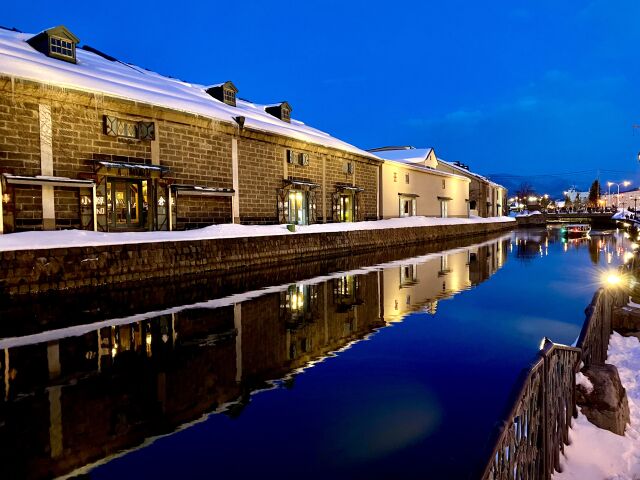
Otaru is also the start of the long road south: Route 5 runs from here down the island to the port city of Hakodate — see Sapporo to Hakodate.
Before you go
- Cape Kamui's gate hours change month to month, and it shuts on strong wind — check the Shakotan tourism association's page the morning you go.
- The Charenka trail to the tip is closed through winter and reopens around the start of April.
- Fill the tank in Otaru or Yoichi; petrol stations thin out west along the peninsula.
- For the Nikka guided tour you must reserve ahead and it is in Japanese; you can still walk in free for the museum, shop and restaurant.
- Fresh uni is a June-to-August thing on this coast — time the trip to it.
- Shakotan blue needs a calm, sunny day; drive the coast in the morning before the wind gets up.
- Base in Otaru, not on the cape — the peninsula itself has little lodging.
Sources, and when I checked them
- Cape Kamui gate hours — Shakotan Town (official) checked 2026-08-13
- Cape Kamui and the Charenka legend — Shakotan Tourism Association checked 2026-08-13
- Niseko–Shakotan–Otaru Kaigan Quasi-National Park, Hokkaido's marine park — Hokkaido Prefecture checked 2026-08-13
- Shimamui Coast — Visit Hokkaido checked 2026-08-13
- Shakotan sea urchin (uni) season — Visit Hokkaido checked 2026-08-13
- Nikka Whisky Yoichi Distillery, visiting and reservations (official) checked 2026-08-13
- National Route 229 — Hokkaido Regional Development Bureau (MLIT) checked 2026-08-13
- Otaru Canal — Visit Hokkaido checked 2026-08-13