Sheet 03 · Southern Hokkaido · Oshima · Route 5
Sapporo to Hakodate, the long way south
Close to three hundred kilometres down the island's southern spine to Hakodate — the paperwork, the coast road versus the toll road, a lake under an active volcano, and the port city with the three-star night view.
Some links in this article are affiliate links: if you book a car or a room through one, I receive a commission at no extra cost to you. It does not change what I recommend.
Hakodate is the far end of Hokkaido, or the near end, depending on which way you are facing. It sits at the bottom of the island’s southern tail, a port city looking across the Tsugaru Strait towards the rest of Japan, and it is close to three hundred kilometres from Sapporo however you measure the drive. That distance is the point of this one. The road south is not something to be got through on the way to the good part — the good part is strung out along it.
There are two ways to make the run, and this is how to do either well: what you need before you take the wheel, the honest difference between the expressway and the coast road, the lake under a volcano that is worth breaking the journey for, and the port city itself — its history, its night view, and the reason you leave the car at the bottom of the mountain.
§ 01
Before the wheel: the car and one piece of paper
Most people who drive in Hokkaido arrive at New Chitose Airport, an hour or so south of Sapporo, and the sensible thing is to pick the car up where you land rather than for this drive alone. Book it at the airport and you have it for the whole trip; drive out through Sapporo and point south. There is no useful way to do this route on public transport, and every good reason to have your own car. Hakodate is the far end of that first day, and the measured driving times from the airport say how much of it is realistic before dark.
One piece of paper matters more than any other. Japan recognises only the International Driving Permit issued under the 1949 Geneva Convention on Road Traffic; the newer 1968 permit that some countries now issue is not accepted here, so check which one yours will be before you fly. It is valid for one year from the day you enter Japan, and you carry it together with your home licence, not instead of it. A handful of countries — Switzerland, Germany, France, Belgium, Monaco and Taiwan — use an official Japanese translation rather than the permit, but the principle is the same: sort the paperwork at home, because you cannot fix it at the rental counter. The permit is only the first thing to settle before you book. The insurance, and what each part of it actually covers, is the other.
§ 02
Two ways down: the toll road and the coast
If you only want to arrive, the expressway does it in about four hours. The Do-Ō Expressway runs south from Sapporo past Noboribetsu and Muroran and hands you to a bypass into Hakodate; reckon on somewhere around ¥6,000 in tolls for a normal car, less with an ETC card and its time-of-day discounts, though the exact figure is worth confirming on the toll search before you set off.
The other way is Route 5, the old national road the expressway was built to relieve, and it is the more interesting line by a wide margin. It threads Otaru, then the resort country under Mount Yōtei — the near-perfect cone locals call the Ezo Fuji — before dropping to the Sea of Japan coast near Oshamambe and following it round through Mori to Onuma. It is slower, and it is meant to be. Do not try to run Sapporo to Hakodate and back in a single day; give it two, break the journey at the lake, and spend a night there or in Hakodate itself. Fill the tank in the larger towns while you are at it — Otaru, Kutchan, Oshamambe, Mori — because the rural stretches and Sunday evenings are no time to be hunting for an open station.
§ 03
Onuma, the lake under the volcano
About half an hour short of Hakodate the road reaches Onuma, and it is the one place on this drive worth stopping for its own sake. Ōnuma Quasi-National Park was set aside in 1958 around three lakes — Ōnuma, Konuma and Junsainuma — formed when Mount Komagatake’s eruptions dammed the rivers below it. Ōnuma alone is scattered with something like a hundred and twenty-six islets, and a chain of small bridges links a handful of them into a walking path you can finish in under an hour, the jagged mountain in view the whole way round.
In 1915 a national newspaper poll named Ōnuma one of the New Three Views of Japan, alongside Miho no Matsubara and the Yabakei gorge, and on a still morning with the mountain doubled in the water you can see the case they made. If you would rather move, a flat cycling loop runs right around Ōnuma — about fourteen kilometres, a little over an hour on a rented bike, with a campground and a shop roughly halfway.
The mountain behind all of it, Komagatake, is an active volcano: 1,131 metres, and still steaming. When it is open to climbers at all it is only in summer, only by a single route, and only as far as a saddle well short of the top — the crater itself stays closed. Check its alert level before you plan anything on its slopes, and enjoy it from the water the rest of the time.
§ 04
Hakodate: the port that opened early
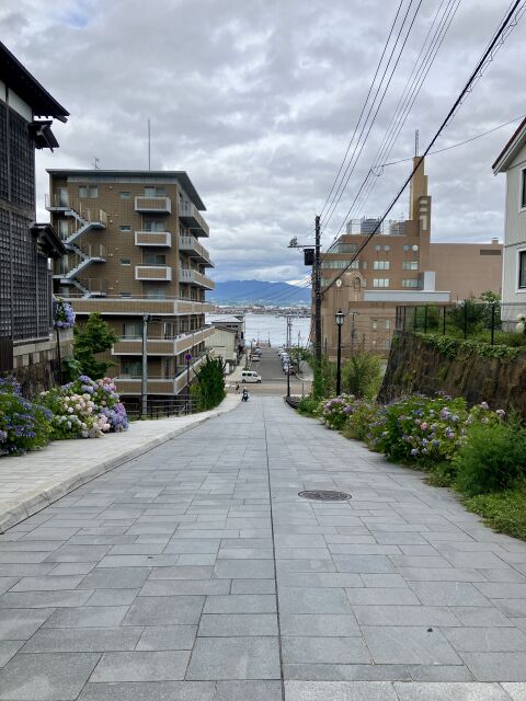
Hakodate was one of the first Japanese ports opened to the outside world. The 1854 Convention of Kanagawa named it a harbour where foreign ships could take on supplies, and in 1859 it opened properly to foreign trade, alongside Yokohama and Nagasaki. That head start is written into the town. Motomachi, the district on the slopes below the mountain, is where it shows most plainly — old consulates and mission churches, the 1910 Old Public Hall in pale blue and yellow, and Hachiman-zaka, the photographed slope that runs straight down to the water. Along the waterfront, the Kanemori Red Brick Warehouses — the buildings you see rebuilt in 1909 after a fire — are shops and restaurants now, but they keep the shape of the trading port.
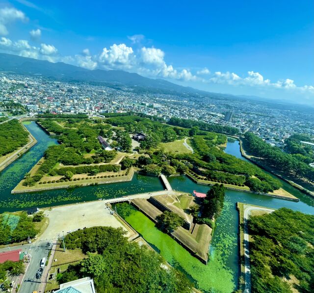
Inland stands the other set piece. Goryōkaku is Japan’s first Western-style fortress, a five-pointed star built between 1857 and 1864 to house the magistrate who managed all this foreign contact. A few years later it became the last stand of the old order — the headquarters of Enomoto Takeaki’s breakaway Republic of Ezo, and the stage for the Battle of Hakodate in 1868–69, the final battle of the war that ended the shogunate. The star only reads as a star from above, so it is best seen from the tower beside it (¥1,200, open nine to six); in spring the ramparts hold some 1,600 cherry trees, the figure everyone quotes.
§ 05
The night view, and why you leave the car below
Hakodate’s night view is the thing it is most famous for, and it earns the reputation. The city sits on a narrow neck of land between two bays, so after dark its lights fan out in an hourglass hemmed by black water on either side. The Michelin Green Guide gives the view three stars, and the city’s own tourist board is happy to rank it among the three best night views in the world, next to Naples and Hong Kong. It is best in the half hour on either side of sunset, when there is still colour in the sky behind the lights.
Here is the practical part, because it catches people out. In season you cannot simply drive up Mount Hakodate in the evening: the summit road is closed to private and rental cars during exactly the hours everyone wants to be up there — roughly five in the evening until the ropeway stops, from spring through autumn. So take the ropeway. It climbs to the 334-metre summit in about three minutes, costs ¥1,800 return for an adult, and runs until 22:00 in summer and 21:00 the rest of the year. One date to note if you travel in late autumn: the ropeway closes for its annual inspection from 20 October to 8 November 2026.
§ 06
Where to eat, where to sleep
Base yourself in Hakodate. It has the range of places to stay that the towns along the way do not, and it puts the night view, the market and Motomachi within easy reach of each other.
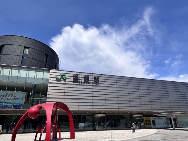
Breakfast is the morning market, a minute from the station and a couple of hundred stalls deep in crab, salmon roe and sea urchin — and squid above all. Hakodate is squid country, and at one corner of the market you can hook a live one from a tank and have it sliced in front of you. The species rotate through the year, so something is nearly always in season rather than none of it. For a late meal, the city’s ramen is shio, salt: clear and restrained, the third corner of Hokkaido’s ramen triangle after Sapporo’s miso and Asahikawa’s soy.
§ 07
When to go
The drive works in every season, with caveats. From roughly late October into April you are on studless tyres and should be reading 北の道ナビ, the official cold-region road service, for blizzard visibility and pass closures — the inland stretch under Yōtei and the exposed Oshamambe–Mori coast are where winter bites hardest. Summer buys the longest ropeway hours and the lake at its greenest; autumn turns Onuma; and in the weeks before Christmas the Hakodate waterfront runs its winter illuminations. Whenever you go, treat the hours and fares here as a starting point and check the current ones before you rely on them — they drift.
This is the southern spine of the island. The same Route 5 that carries you down runs through Otaru, where a different coast road turns west for the cliffs and blue water out to Cape Kamui; and inland, the patchwork hills of Furano and Biei are the other drive most people pair with this one. Halfway down, a short crossing runs inland from the expressway into volcano country xE2x80x94 Noboribetsu to Lake Toya, over Orofure. Between them, they are most of the reason to keep the car a few extra days.
Before you go
- Rent the car where you land — most flights come into New Chitose, about an hour south of Sapporo.
- Carry an International Driving Permit issued under the 1949 Geneva Convention; the 1968 version is not accepted in Japan.
- Give the trip two days if you can — one to drive down by way of Onuma, one for Hakodate.
- In winter (roughly late October to April) expect studless tyres and check 北の道ナビ for pass and blizzard conditions.
- You cannot drive up Mount Hakodate in the evening in season — take the ropeway or the bus for the night view.
- If you travel 20 October–8 November 2026, note the Mount Hakodate ropeway's annual inspection closure.
- Check Mount Komagatake's volcanic alert level before planning any walk on its slopes.
- Reconfirm hours, fares and tolls before you travel; they change.
Sources, and when I checked them
- Ōnuma Quasi-National Park — Hokkaido Prefecture (official) checked 2026-08-15
- Mount Komagatake climbing and access, FY2026 — Mori Town (official) checked 2026-08-15
- Mt Hakodate Ropeway — hours, fares and summit-road restriction (official) checked 2026-08-15
- Mt Hakodate Ropeway — 2026 schedule and car restriction (official) checked 2026-08-15
- Goryōkaku Tower — history and visiting (official) checked 2026-08-15
- Hakodate city tourism (Hakobura, official) checked 2026-08-15
- Hakodate Morning Market (official) checked 2026-08-15
- Driving in Japan and the International Driving Permit — JAF (official) checked 2026-08-15
- Kita-no-Michi Navi, winter road information — CERI (official) checked 2026-08-15