Sheet 04 · Southern Hokkaido · Iburi · Hokkaido Route 2
Noboribetsu to Lake Toya, the volcano road
Forty-six kilometres from a boiling crater to a caldera lake, over a pass that tops out just under nine hundred metres — hell valley and its ten waters, the Orofure climb, a mountain that redrew the map three times in a century, and fireworks every night until the end of October.
Some links in this article are affiliate links: if you book a car or a room through one, I receive a commission at no extra cost to you. It does not change what I recommend.
An hour and a half south-west of Sapporo the island stops pretending to be farmland. The ground steams, the rock is the colour of rust, and twice in the last century it has rearranged itself badly enough to move a road. The drive between Noboribetsu and Lake Tōya runs straight through the middle of that — forty-six kilometres, about an hour if you do not stop, and you will stop. At one end is a crater that has been boiling since before anyone kept records. At the other is a caldera lake with an active volcano on its rim and a town built at the volcano’s feet anyway. In between is Orofure, the only climb on this sheet that asks anything of the car.
It is a short drive with a great deal packed into it, which is the argument for giving it a whole day rather than treating it as a transfer between two hot spring towns. This is the order I would take it in: the hell valley and its water first thing, the pass in the middle of the day while the view is open, and the lake in the late afternoon — because from the end of April the fireworks go up at a quarter to nine, every single night, and it would be a pity to arrive at ten.
§ 01
Hell Valley, and the water the town is built on
Noboribetsu Onsen is a single street of large hotels wedged into a side valley, and the thing that put it there sits just above the top of the road. Jigokudani — Hell Valley — is the floor of an old explosion crater about 450 metres across, bare and rust-red, venting steam out of a hundred seams at once. Something on the order of ten thousand tonnes of hot water a day comes out of this one basin, which is what a town of that many baths runs on. It is inside Shikotsu-Tōya National Park, and a boardwalk takes you out over the middle of it to a small vent that surges on its own schedule. There is no ticket. You simply walk in, and the smell arrives before you do.
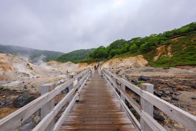
What is unusual here is not the steam but the chemistry. Several chemically distinct waters surface within a few hundred metres of each other — sulphur, iron, salt, alum, acid — which is why the place gets called a department store of hot springs, and why the local tourist association’s own guide to the water runs to ten separate stories. Hotels advertise which of them they have plumbed the way a wine list advertises regions. If you are staying a night, that is the thing worth choosing on.
Walk on up the hill, twenty minutes or so through the birch, and the ground opens again at Ōyunuma: a gourd-shaped pond about a kilometre round, sitting in a second explosion crater. The bottom of it is a sulphur spring at roughly 130 °C. The surface, where the layers mix and cool, runs somewhere around 40 to 50 °C, and it moves — slate-grey, slightly oily, always turning over. What drains out of it runs downhill through the woods and becomes the best free thing in the district: the Ōyunuma river footbath, where the path meets the stream, there are benches along the bank, and you take your boots off and put your feet in a river that is the right temperature by accident. Bring a towel; nobody sells you one.
One practical note that saves money and a walk. The Jigokudani car park has 165 spaces and is paid, and there is a second car park up at Ōyunuma in the warm months — but pay at either one and the other is free the same day. So park once, walk the valley, and drive up rather than back-tracking on foot in the heat.
§ 02
Over Orofure
The road west out of the onsen is Hokkaido Route 2, the Tōyako–Noboribetsu line, and it starts climbing more or less at the last hotel. From the Jigokudani car park at about 200 metres it takes 46 kilometres to reach the shore of Lake Tōya at 84, and in between it goes up to a shade under 900. The profile at the foot of this page is sampled every 200 metres off the national ten-metre elevation model, so you can see exactly where the work is: a long, steady, unspectacular pull for the first twelve kilometres, and then the real climb in the last three before the top.
The summit is a tunnel, and this is where the pass gets confusing. Orofure Pass proper is the old road above the tunnel, at about 930 metres, where there is a lookout with the splendid name Daikanbō — the great view — which on a clear day reads across to Lake Tōya and the cone of Mount Yōtei one way and out to the Pacific the other. The through road beneath it never gets that high: it enters the tunnel at about 790 metres, comes out the far side at about 800, and then, counter-intuitively, keeps climbing on the Tōya side to a high point near 890 before it lets go and drops in hairpins toward Sōbetsu. Orofure-yama itself, the peak on the north shoulder, is 1,230.7 metres.
Two things to know before you commit to this road, because it is not an all-weather road in the way the expressway is. In recent winters it has been closed to through traffic overnight — roughly five in the evening until nine the following morning — through the snow season, and it shuts outright in bad weather at any hour; the old road up to the lookout stays closed far longer and only opens well into spring. Check the current notice before you rely on it. If the pass is shut, the alternative is the expressway round by Muroran, which is the better part of an hour longer and none of the same thing. You also drive through four snow sheds on the upper section, which is a fair description of what winter does up here.
§ 03
A hole in the ground, 110,000 years old
You come round the last bend and Lake Tōya is simply there, filling its own crater. The caldera was blown out about 110,000 years ago and the lake that settled into it is nearly circular: 70.72 square kilometres of water, 179.7 metres deep at the deepest sounding, sitting at 84 metres above the sea, and clear — a survey at the deep point read 13 metres of transparency. The islands in the middle, Nakajima, are lava domes that came up later through the floor of the lake.
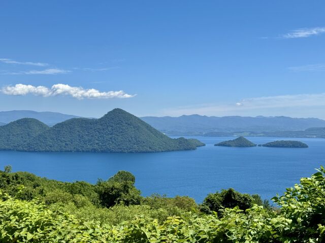
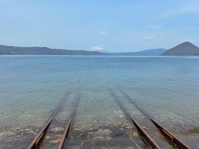
It also does not freeze. Hokkaido has exactly two lakes of any size that stay open all winter, Tōya and Shikotsu, and the reason is not warm springs but arithmetic: they are deep enough, and hold enough water, that the whole column never cools through before spring arrives. In February, when everything around it is white and the sea ice is coming down onto the Okhotsk coast four hours north, the lake is still black and moving. It is a strange thing to stand in front of.
§ 04
The mountain that keeps redrawing the map
The volcano on the lake’s southern rim is Usu, and it is one of the busiest in Japan: at least nine confirmed eruptions since 1663, four of them in the twentieth century alone — 1910, 1944–45, 1977–78 and 2000. The whole region is a UNESCO Global Geopark for exactly this reason. It was designated in August 2009, one of the first in the country, and became a UNESCO Global Geopark when the label was created in 2015. Its theme is not scenery. It is coexistence with an earth that keeps changing under you.
The best short story in the whole geopark is Shōwa-shinzan, the raw brown dome standing in a field on the south-east side. In December 1943 that field was growing wheat. Over the next two years the ground beneath it lifted and a lava dome pushed out of it to 398 metres, in the middle of a war, with no scientific programme anywhere near it. The local postmaster, Masao Mimatsu, watched it from his office and drew it — the same viewpoint, over and over, week after week, against a fixed horizontal line — and the resulting chart, the Mimatsu Diagram, is the reason the birth of that mountain is documented at all. In 1946 he bought the land with his own money so nobody could quarry it. It is still privately owned, still off limits to climbers, and a Special Natural Monument. You can look at it from the field, or ride the ropeway on the mountain opposite for the view down into Usu’s crater — about six minutes each way, ¥2,000 return for an adult.
Then there is the fact the whole district quietly turns on. On 28 March 2000, just after midnight, the first volcanic information was issued. On 31 March, a little after half past eleven in the morning, Usu erupted through its north-west flank, and at seven minutes past one there was a magma–phreatic explosion. Up to 15,815 people were under evacuation orders or advisories. There were no casualties. Not few — none. Everybody had already gone.
§ 05
Walking through the 2000 eruption
What makes this stop worth a couple of hours rather than a photograph is that the town left the damage where it fell. Two short trails run through it. At the Nishiyama craters, a timber walkway crosses what used to be National Route 230: the highway is now a pond in a hole, the asphalt breaks into steps where the ground lifted several metres, and a piece of abandoned plant sits where it stopped. At Konpira, closer to the hot spring street, a paved path runs past a public bathhouse and a block of municipal flats hit by the eruption, and a bridge that a debris flow took out. Both are free, and both are seasonal — in recent years open from 25 April to 31 October, gates at nine and locked at four, and closed at short notice when the crews are working. The Volcano Science Museum by the lake fills in the rest with footage of the 1977 and 2000 events; it is open nine to five, ten to four from October to March, closed Mondays, and charges a modest admission that was revised in April 2025. The visitor centre attached to it is free.
§ 06
Fireworks, every night, for half the year
The other thing about Tōyako Onsen is completely unlike the rest of it. From 28 April to 31 October 2026, every night, boats go out and put up about 450 shells over the water starting at 20:45 and running about twenty minutes — and because the boats move, roughly two kilometres along the shore, the display comes to you rather than the other way round. There is no ticket and no seating plan. You stand on the promenade, or you watch from a bath, or you pay a lakeside room the compliment of leaving the curtains open. It is the longest-running fireworks display in the country, and it is the single strongest reason to stay the night here rather than push on.
§ 07
The car, and where to sleep
There is no sensible way to do this drive without a car — the pass has no bus over it worth planning around — and the practical place to pick one up is the airport you land at. Book it at New Chitose, which is about an hour and a quarter from Noboribetsu on the expressway, and keep it for the rest of the trip. What to add to that booking is a separate question, and which of the add-ons actually protects you is not obvious at the counter. That hour and a quarter starts at the rental branch, not at the gate, and the branch keeps its own hours.
Where you sleep decides how the day reads. A night in Noboribetsu Onsen buys you the valley in the early morning, before the coaches, when the steam still hangs in the trees. A night at Tōyako Onsen buys you the fireworks and the lake at first light. If you can only take one, take the lake, and do the valley on your way through.
§ 08
When to go
Late April to the end of October is when this drive is complete: the trails are open, the fireworks are running, and the pass is doing normal daytime hours. Summer is busy and green and the footbath is at its best. October is the pick if you only want one month — the pass turns colour early at 900 metres, the crowds have gone, and the fireworks run to the very last night of the month. Winter is a different proposition: the two hot spring towns are at their best in snow, but the pass between them may be shut when you want it, so plan the long way round by the expressway and treat Orofure as a bonus if the gate is open.
This sheet sits in the middle of the southern loop. The main road down the island from Sapporo to Hakodate passes within sight of both ends of it, and if you are coming from the north-west, the coast road out to Cape Kamui makes the obvious pairing — blue water one day, boiling ground the next. Whichever way you arrive, check the hours, the seasons and the road notices before you set out. On this particular drive, more of them move than usual.
If the volcanoes are what you came for, the other place on the island that does this at scale is the far east: Abashiri to Kushiro across the three caldera lakes is the same geology written much larger, with a caldera twenty kilometres wide instead of ten and a crater lake you cannot get down to at all.
Noboribetsu Onsen to Lake Toya. The tunnel road tops out near 890 m; the old road over the top, with the Daikanbo lookout at about 930 m, opens only in late spring. Closed to through traffic overnight through the snow season, and in bad weather at any hour.
Before you go
- Pick the car up at New Chitose xE2x80x94 there is no bus over Orofure worth planning a day around.
- Carry an International Driving Permit issued under the 1949 Geneva Convention; the 1968 version is not accepted in Japan.
- Check the Orofure Pass notice before you set out: it has been closed overnight through the snow season, and it shuts outright in bad weather.
- Pay for parking once at Noboribetsu xE2x80x94 the Jigokudani and Oyunuma car parks credit each other the same day.
- Take a small towel for the Oyunuma river footbath. Nothing is sold at the bank.
- The Nishiyama and Konpira crater trails are seasonal xE2x80x94 in recent years 25 April to 31 October, gates locked at four.
- Fireworks run nightly from 28 April to 31 October 2026, starting 20:45; worth timing the second half of the day around.
- Reconfirm hours, fares and seasons before you travel. On this drive more of them move than usual.
Sources, and when I checked them
- Noboribetsu Jigokudani xE2x80x94 HOKKAIDO LOVE! (official) checked 2026-08-20
- The waters of Noboribetsu Onsen xE2x80x94 Noboribetsu International Tourism and Convention Association (official) checked 2026-08-20
- Toya-Usu UNESCO Global Geopark xE2x80x94 designation (official) checked 2026-08-20
- Toya-Usu Geopark xE2x80x94 caldera age and eruption record (official) checked 2026-08-20
- Lake Toya survey data xE2x80x94 Hokkaido Research Organization (official) checked 2026-08-20
- Why Shikotsu and Toya do not freeze xE2x80x94 Hokkaido Research Organization (official) checked 2026-08-20
- The 2000 Mount Usu eruption, disaster response record xE2x80x94 Cabinet Office, Disaster Management (official) checked 2026-08-20
- Konpira crater trail, season and hours xE2x80x94 Toyako Town (official) checked 2026-08-20
- Nishiyama crater trail, season xE2x80x94 Toyako Town (official) checked 2026-08-20
- Toyako Visitor Center and Volcano Science Museum xE2x80x94 hours and admission notice (official) checked 2026-08-20
- Usuzan Ropeway xE2x80x94 fares and seasonal hours (official) checked 2026-08-20
- Showa-shinzan and Masao Mimatsu xE2x80x94 Sobetsu Town (official) checked 2026-08-20
- Lake Toya Long-run Fireworks, 2026 dates xE2x80x94 HOKKAIDO LOVE! (official) checked 2026-08-20
- Elevation model used for the pass profile (DEM10B) xE2x80x94 Geospatial Information Authority of Japan (official) checked 2026-08-20
- Kita-no-Michi Navi, winter and pass road information xE2x80x94 CERI (official) checked 2026-08-20